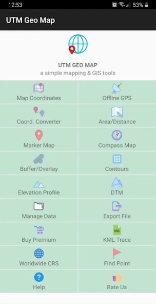
About UTM Geo Map
Complete, simple, easy to use & free application for Land Surveying, Topography, Bathymetry & GIS. Suitable for Geodesy Engineering, Civil Engineering, Geology and other disciplines related to maps, coordinates, location,...
Complete, simple, easy to use & free application for Land Surveying, Topography, Bathymetry & GIS. Suitable for Geodesy Engineering, Civil Engineering, Geology and other disciplines related to maps, coordinates, location, address and spatial analysis. Can be used as a tool in determining position, coordinates, location & address, area & distance measurement, simple spatial analysis such as Overlay, Buffering, TIN / Delaunay Triangulation, Voronoi Diagram, Convex Hull, Smoothing, show WMS Map (Map Server) etc.
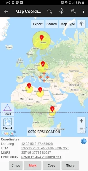
Map Coordinates : Can be used to obtain Latitude Longitude, UTM, MGRS (WGS84) & other CRS (using EPSG codes) in real time, register points complete with coordinate data, time taken, notes/labels, elevation (premium), addresses, photos etc. This module can also display TIN, Voronoi Diagrams and Buffers in realtime from existing points.
Offline GPS : Used to get coordinates in an offline state (without internet access), your cellphone will function like a Handheld GPS to get Latitude Longitude coordinates, UTM, MGRS, Elevation (ellipsoid), MSL Elevation (EGM96), accuracy, satellite and other useful information. Coordinates data can be stored in an unlimited number inside your databases, given notes / labels, photos or exported into CSV, KML, DXF & GPX formats.
Coord. Converter : To convert coordinates manually from Latitude Longitude to UTM & MGRS and vice versa. It can also be used to convert addresses to coordinates (Geocoding, requires an internet connection). Some conversion is support for batch conversion.
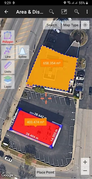
Area/Distance : Used to measure distance and area (support units: m, km, ft, miles, hectare, acre), register lines / polygons, make polygons automatically from measure points, create buffers from lines / polygons, overlay etc.. Line / polygon data can be stored in unlimited number inside your database, displayed on a map, added photos and labels or exported to CSV, KML or DXF format. Equipped with spatial editing algorithms such as Snap Nearest, Delete Object Inside / Outside Polygon, Smoothing (cubic bezier interpolation), Split Polygon By Line, and so on. Can read CSV & KML formats to import or display as reference files.
Marker Map : Similar to the
Map Coordinates module but with more complete & complex geometry calculation such as displaying Dynamic / Variable Buffers. In this module geometric analysis such as TIN & Voronoi Diagrams can be made from a combination of point data (markers) as well as lines and polygons (breakline). These geometries can also be exported to KML or DXF files for use on other devices or PC.
Compass Map : Module with a map and compass with magnetic declination, can be used to assist in navigating or measuring the azimuth angle and determining distance & direction.
Buffer/Overlay : Module to perform buffering & overlays (and other GIS operations) with several options including Union, Intersection, Difference and Symmetrical Difference.
Elevation Profile : Used to create simple elevation profiles (cross section / long section) from height data with metric & ft / mile units. This module can also create elevation profiles from multiple points including elevation profile from route (premium).
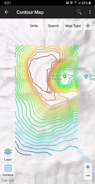
Contours : Module to generate contours based on number of contour lines, desired elevation or contour interval. This is premium module & need internet connection.
DTM : Digital Terrain Model, module to generate TIN / GRID surface & Contour Lines from elevation data. Calculate Cut And Fill volume, TIN refinement, Grid interpolation and dynamic Elevation Profile.
Some other modules.
Website: https://www.utmgeomap.com
Quick guide (pdf): https://www.utmgeomap.com/utmgeomapquickstart.pdf
YouTube: https://www.youtube.com/channel/UCspxQ5nQiqRD88g_-6GcCqw
Any suggestions are welcome, please submit via email to
[email protected] or write a review. Thanks.
Previous Versions
Here you can find the changelog of UTM Geo Map since it was posted on our website on 2019-07-18 18:18:05.
The latest version is 4.0.2 and it was updated on 2024-04-23 10:38:40. See below the changes in each version.
UTM Geo Map version 4.0.2
Updated At: 2024-04-08
Changes: This version comes with lots of backend improvements. Happy mapping!.
UTM Geo Map version 3.9.9
Updated At: 2024-03-17
Changes: DXF file compatibility improvements.
UTM Geo Map version 3.9.6
Updated At: 2024-03-01
Changes: Bug fix.
UTM Geo Map version 3.9.3
Updated At: 2024-01-26
Changes: Create separate Project to make it easier for you to organize data, especially for large amounts of data.
UTM Geo Map version 3.9.2
Updated At: 2023-11-25
Changes: Faster CRS calculation.
UTM Geo Map version 3.9.0
Updated At: 2023-11-14
Changes: Fix bugs on snap nearest.
Add more photos to the data.
Some other improvements.
UTM Geo Map version 3.8.4
Updated At: 2023-08-02
Changes: Polygon Hole Inside.
UTM Geo Map version 3.8.7
Updated At: 2023-08-02
Changes: Bug fixes.
UTM Geo Map version 3.8.3
Updated At: 2023-07-10
Changes: Fix bug APP crash when showing polygon labels (for older android versions).
Fix bug APP crash when showing color picker (for some devices).
UTM Geo Map version 3.7.9
Updated At: 2023-02-28
Changes: Improvements on import CSV, support more CSV format.
Segment length.
Contour elevation label.
Disclaimer
Official Google Play Link
We do not host UTM Geo Map on our servers. We did not scan it for viruses, adware, spyware or other type of malware. This app is hosted by Google and passed their terms and conditions to be listed there. We recommend caution when installing it.
The Google Play link for UTM Geo Map is provided to you by apps112.com without any warranties, representations or guarantees of any kind, so access it at your own risk.
If you have questions regarding this particular app contact the publisher directly. For questions about the functionalities of apps112.com contact us.